
Stewart, one of my most stalwart paddling buddies, after a solo run on the Lower Meadow.
Glad his better half had a nice warm car waiting for him.
.jpg)


.jpg)
.jpg)
.jpg) Adam Johnson finishing up Tomko. The standard left line ( a 6 or 8' boof, driving right) on the bottom falls has a log in it. It is covered at higher flows, but in the low 200cfs range we had, it sticks out into the line. We ran center.
Adam Johnson finishing up Tomko. The standard left line ( a 6 or 8' boof, driving right) on the bottom falls has a log in it. It is covered at higher flows, but in the low 200cfs range we had, it sticks out into the line. We ran center..jpg) Wide view of Flatliner Falls, the site of a fatal accident on October 1. The line is to boof straight, off the furthest protrusion of the ledge. You are fighting the flow and gravity as you come around the corner and drive to the point. At the time of the accident, there was aproximately 400cfs in the river, almost double the flow pictured here.
Wide view of Flatliner Falls, the site of a fatal accident on October 1. The line is to boof straight, off the furthest protrusion of the ledge. You are fighting the flow and gravity as you come around the corner and drive to the point. At the time of the accident, there was aproximately 400cfs in the river, almost double the flow pictured here..jpg) From above, showing the tilt of the ledge to the left.
From above, showing the tilt of the ledge to the left..jpg) The pin spot/pocket is in the center of the photo. There have been several non-fatal pins here prior to Friday's drowning.
The pin spot/pocket is in the center of the photo. There have been several non-fatal pins here prior to Friday's drowning..jpg) Log in the Turncoat boof crack, on the far right entrance to "My Nerves are shot, I can't take it anymore" Its good the crack is filled, but the log could definitely spoil a line if you are unaware of it.
Log in the Turncoat boof crack, on the far right entrance to "My Nerves are shot, I can't take it anymore" Its good the crack is filled, but the log could definitely spoil a line if you are unaware of it.
 Someone else had already done some work just above here, thanks whoever you are! This one was in the run-out of the creek, just above the old takeout slide.
.jpg) Isaac with my Dad in the doldrums. Every wave that crashed on our duckie was met with a gleeful "Do it again!". Just like his big brother.
Isaac with my Dad in the doldrums. Every wave that crashed on our duckie was met with a gleeful "Do it again!". Just like his big brother..jpg)
.jpg)
.jpg)
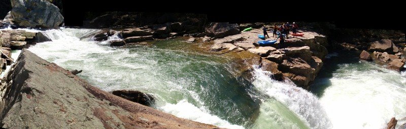
.jpg) Almost everyone looking at the camera.
Almost everyone looking at the camera.

| Paddler | Time | Boat | Note |
|---|---|---|---|
| Jason Beakes | 8:45 | Green Boat | That is Fast |
| Matt Fithian | 9:30 | Green Boat | |
| Brian Menzies | 9:32 | Green Boat | |
| Sam Kane | 9:35 | Green Boat | |
| Jay Ditty | 9:44 | Response C-1 | |
| Jon Harmon | 9:45 | Green Boat | |
| Adam Johnson | 9:54 | Magnum | Fastest shortboat |
| Charlie Bartlett | 10:00 | Karnali | |
| Nathan Sass | 10:06 | Green Boat | |
| Clay Warren | 10:23 | Green Boat | |
| Nori Onishi | 10:39 | Jefe | Fastest Asian |
| JB Seay | 10:41 | Burn | Slowest Asian |
| Roger Loughne | 10:45 | Jefe | |
| Billy Clipper | 10:50 | Nomad | Handpaddle Champ |
| Cody Walsh | 11:09 |


 The second significant drop: a transition onto a slab and then out.
 Busy Busy Busy.
 Whoah. Long day for this man, but he did it with a smile and a game effort. Big boat on a little creek.
 Sam Burke in one of the more boulder filled rapids on the upper section of creek. The rock to Sam's left dished out a lot of abuse, from scraped knuckles to full on swims. Above this drop is a 12' falls, and a 10' slide, and some other stuff all in sequence with no real stop. I ran it on verbal directions from Chuck, who got them from Mike Moore, who spent much of the day standing on various perches giving out directions like an air traffic controller. (or a mountaintop guru of rapid lines) Beta from Mike, and from Don Smith, who had also been on the creek previously, made for confident probing and bombing away.
 Chuck Morris keeping his bow up in a tight LZ. Just below this ledge is a large, broken tree spanning the river. While you portage around the tree, you can take a moment to scout the confluence canyon.
 Don Smith runs the second of three drops in this sweet little crux gorge. 20' entrance falls, a 12' or so kicker in the middle, then a twisting slide to exit. At this point on the run, you have traveled about 1/2 a mile and dropped 400'. Awesome.
 Geoff Calhoun finishes up the third slide.
 By really fast I mean we didn't scout here.
 Or here. Or countless other ledges and turns. The work Mike and crew did, the super friendly nature of the creek, and some very comfortable probes out front made quick work of the bottom 1 1/2 miles of creek, which were still dropping at a 400-500fpm pace.
 Mild mannered elementary school teacher Robert Miller genteelly makes his way down a babbling brook.
 Don Smith loads up for the best boof on the creek. Taller than it looks.
 Eric Amason charges around the corner and prepares to log dodge.