Sunday, May 11, 2008
A complete and total skunking.
9:30am Depart Morgantown with entire family.
10am: My brand name roof rack system came apart on the interstate, sending my kayak cartwheeling across the roof of my car, down the side (where it smashed a window right behind my 3yr old son's head) and onto the asphalt at about 80mph.
It passed me as I stopped on the shoulder of the road. Sounded like when the videobaters go down the steps at Cunard.
I think, "Okay, everyones fine, the boat's not broken, I can save this". I finished the drive to my mom's in Clarksburg, dropped the boys off with their Grandma, and took off in her truck, bound for Canaan and the joys of gravity. Taping up the car window and getting my mom's truck ready took a little while, but I can still make it. Its about 11am.
Stop and get a sandwich in Elkins, smell antifreeze, and find the upper radiator hose has a hole in it. I hurry to an Advance auto parts, change the hose, and have the truck running and topped off with coolant again. It is now 12:30 and I'm freaking a little.
Finally arrive at the Red Creek take out at 1:10 or so, and see a bunch of cars, including Don's. He is about 20 minutes ahead of me, and I figure I can still catch them on the hike or at least in the paddle-in to the steeps. I CAN STILL SAVE THIS!
Halfway up the mountain I realize I don't have a skirt.
I'm Doomed.
Why I forgot to put it in the gearbag, i don't know, but it ain't there. I drive on, hoping to catch someone with a spare at the put in, but no luck.
Back down the mountain, and I leave a note on Don's car. I'm sorry you had to wait so long man.
Decide to head for the North Fork of the Blackwater, hoping to borrow a skirt there for a quick run, but on the way out I discover the fuel gauge does not work below 1/2 a tank and run out of gas.
2:30pm: take a pleasant walk on a country road with my wife.
3:30pm:depart Canaan with my tail between my legs, and hope for better luck next time.
Thursday, December 13, 2007
Exploring

This creek was at least 600fpm, enough that only one person would be able to boat at a time, so we used a hybrid aproach to the creek: 1 kayak between us, and no shuttle; hike in, boat, hike out.
It ended up being a 3.5 mile round trip hike with about 600 feet of loss and climb back up. Not much Rhododendron, but the soil was so wet that we had to traverse or use trees and such to climb; going straight up unaided was not possible. Great scenery, good workout, but no kayaking due to wood and VERY continuous large rapids. A volleyball net to stretch across the creek would've come in handy as a backstop.
First major drop. I would have run this but for the trees. Its about 20 feet tall.

Downstream, things really picked up;

Wednesday, June 13, 2007
Cheat River Narrows
I took my 8month pregnant wife and 2 year old son on a duckie trip to the Cheat Narrows .
This section of the Cheat features pleasant pool drop rapids, roadside access, pretty scenery, and less environmental damage than the Canyon downstream; the Narrows sustains fish and other aquatic life, and has normal colored rocks. That’s not to say that it doesn’t have threats; several AMD laden creeks run into the Narrows, and agricultural runoff and other problems always lurk. BUT, I saw a fisherman land a pretty little trout on our run, and that’s not something you see a few miles downstream.
We met up with Janet and Kristina Szilagyi in Kingwood, and headed down over the hill to the river. We dropped and inflated gear, then set shuttle to take out where Pringle Run flows into the Cheat.
Patrick was stoked.

Rebecca sat up front, I sat in back and Patrick sat between my feet. He giggled and yelled “FUN!” when we went through rapids, and even stole Rebecca’s paddle so he could help Daddy. He’s awesome.

Janet and Kristina in a calm spot.

I asked Kristina to take our picture in Calamity Rock Rapids, and while I waited for her and Janet to get downstream and set up, I bank scouted the rapid, to be extra double super sure of where I would pilot the boat. Kristina took a fun shot of us.
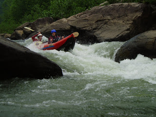
At the Mystery spot below Calamity, I plopped out the back of the boat and caught some nice downtime. Patrick was pretty surprised, and yelled "Daddy... get back in boat right...NOW!" in his best scolding voice. We finished up the trip in a pleasant hour and a half, Kristina rescued a runaway pool-croc at the take out, and a good time was had by all.
Thursday, March 01, 2007
Deckers Creek
 With a demanding job schedule, a 2 year old and a fixer upper kind of house, my boating availability is sometimes limited. I've chosen quality over quantity, so when I get out its generally on something good. Fortunately for me, Deckers Creek is 10 minutes from my house, and runs pretty frequently.
When I was a undergrad student at WVU, there was a serious crowd of boaters who would be out on Deckers pretty much everytime it ran. That group has moved on, landed full-time jobs, wives, babies, etc.. Its a lot harder to find people out there anymore. Part of that may be bacause even though Deckers creek is a roadside run, it carries a lot of dangers. It is a sandstone boulder pile, with a just a bit of bedrock at the bottom. It is similiar in nature to Manns creek for its hazards. Gaping sieves and undercuts line the run, with many rapids requiring very precise or unusual lines. Two major pourovers have 10' deep caves behind/under the curtain.
 This is towards the top of the run. Deduction is the largest rapid partially visible behind the hemlock at the top of shot. Carcass is at the very bottom.
A few weeks ago my good friend Stewart Caldwell snuck into town and we hit up Deckers on a cold (in the 20's) day. Stewart is one of my favorite paddling partners. He has run just about everything you can boat in WV, including 1st descents, and is as reliable as they come when the water pours downhill. The water level was pretty much perfect: 300cfs, on the USGS Gage. We put in at a roadside pullout, being careful not to step on this guy:
 I don't think I've ever run Deckers without seeing a dead deer. Its kind of like good luck!
Notice the icicles. Several limbo logs on the run had big fat ones hanging down from them, requiring the lead boater to play icebreaker.
 Kayaking access was probably not in the Lions Club's intentions when they took over this park, but... Thanks Guys!
This run consists of a flume drop, an automatic-stern-first-big-air-boof waterfall, a clunkier falls, and then the final waterfall pictured below. Total drop is around 100 feet in just a short section. It is geologically similiar to the NF Blackwater, and has a larger window of boatable flows than the lower section; the upper limit really depends solely on your tolerance for large holes.
You can see Jared's take of the afternoon, with additional photos, on the Team Pyranha website.
Monday, November 20, 2006
Late Fall Upper Blackwater
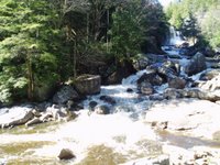
We droppped the bike in Douglas, and circled back around to the put-in. Upon arrival, it was confirmed that the Blackwater was low. Like 200 cfs or less low. Oh well, it still goes, and it was blue skies and high 50's. The photo at left is looking back up toward Blackwater Falls from the put-in. Most trips begin in the foreground eddy. The brown color of the water is not mud, but tannic acid, leached out of spruce, pine, and hemlock tree detrious in the headwaters of the river. This river and Red Creek and Red Run of Canaan derive their names from the tea-like appearance.
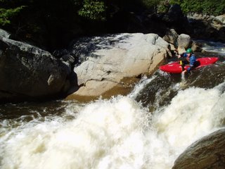 Ben Dunham running 100 Yard Dash, the first rapid of our run. The move Ben is making comes immediately out of the put-in eddy.
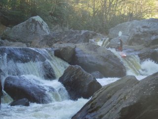 Ben Badger finishing off Tomko Falls. Higher water opens up several other lines.
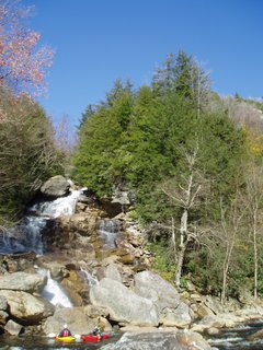 Ben and Ben at the bottom of Pendleton Falls.
 Ben Badger on the final ledge of My Nerves are shot, I can't take it anymore. The perspective afforded by my point and shoot does not do this rare bedrock rapid justice. The uppermost ledge visible in the photo drops 10-12 feet and is 50-60 yards away.
 Ben Dunham climbing the hill from the Blackwater/North Fork confluence to the old railroad grade. 500 feet up and then a mile back to the parking area.
My priveledge for being the first back; shuttle biker. To save fuel, get more exercise, and enjoy company on the drive, we used a bicycle for the shuttle. The ride took about 40 minutes on the cross country bike. Single speed bike= great for the woods, slow on the Blue Highways. I was peevishly honked at/flipped off once, and a pick-up truck accelerated angrily around me, over corrected onto the shoulder, and nearly flipped into an oncoming Tahoe. Exciting.
.jpg)

