.jpg)
The plan was to meet Ed Gaker and Adam Johnson in California, and hopefully hook up with our friend Oliver Grossman for logistical help and some boating around his work schedule.
We wanted to try for Upper Cherry, and if it was too high, do day trips or maybe West Cherry.
I had my Westbound ticket bought, and was looking for the return flight when I got terrible news: Ed had drowned boating in Colorado. (I wrote some about this in a previous post) I struggled mightily with what to do about my trip, and looked into giving my ticket away and just letting this one go. In the end I decided to proceed, confident Ed would have wanted it that way (cliche or not it's true), but with a heavy heart.
On Thursday the 11th I shipped my kayak west to safeguard against any airline snafu's.
Friday a bunch of us drove to central Ohio to attend Ed's viewing, and his memorial on Saturday.
Sunday and Monday my wife and I packed up our house and moved 3 hours East, to the Panhandle of WV.
Tuesday I flew to Sacramento.
I got there late Tuesday night, and Adam picked me up, with my kayak already on top of the car. We headed south, checked in with Oliver, and confirmed that we would meet somewhere near the Kaweah the next morning.
We got to Three Rivers, just outside Sequoia National Park, around 4:30 in the morning. I slept in the back of the car for about 2 hours, then got up to get a snack and call the wife to let her know I was there and safe. I dozed some more until about 7:30, when Oliver met us and we went to breakfast.
We saw a car with boats and Oregon tags, so I went over to say hello. I asked the guy standing there if he was Chris (Korbulic) as we have a number of friends in common. Oops. It was actually Ben Stookesberry, with Darin McQuoid riding shotgun. We chatted a bit and quizzed them on levels, before hitting the road. Nice guys. They had just completed the 3rd or 4th decent of the Upper Middle Fork, hiking several hours upstream from the end of the road.
We were unsure of put-ins and take-outs, but Adam remembered paddling all the sections of the Middle Fork of the Kaweah, so we figured we could run the whole river, and loath to pay for two cars to get in the park, we left a car in town. We drove into Sequoia National Park, and ended up meeting with a group of 6 guys from the U.K. (who had no more info than us), and we put on at the Paradise Creek Trail bridge, just above the Buckeye Flats campground.
.jpg) Just a few short drops around a corner, and we were at Chuck's (Kern) Drop. Its big, shallow and gets run occasionally.
Just a few short drops around a corner, and we were at Chuck's (Kern) Drop. Its big, shallow and gets run occasionally. Not by us though. Bill Anderson portaging Chuck's Drop. We dropped one team member who wasn't feeling well here, bringing us down to 8 first timers* on the run.
*Adam had run the Kaweah in high school, but when mixed in with the memories of their 200+ days a year paddling pace, he was fuzzy on where things were. Sometimes, at the bottom of a drop he would say "Oh yeah, I remember that one" but that was the extent of his beta.
 The first drop of any size below Chucks. JB Seay, photo by Oliver Grossman.
.jpg) Oliver Grossman runs the same.
Oliver Grossman runs the same.More fun read and run brought us to a series of slides in a mini-canyon. We scouted from the river left, climbing on top of a house sized boulder perched on the bedrock. 2/3 of the flow went under the rock, but the left channel around was easy to make at low water.
Oliver and I headed up and ran the first few slides.
 While eddied out under an overhang, I found this rock in the embrace of the roots of a sycamore tree.
 Bill Anderson on Drop #2 in the series.
Drop #3 and 4, showing the rather large sieve. Photo by Oliver Grossman.
Once we got everyone worked through here, we portaged around a messy rock pile just below. Just a few eddies downstream and we arrived at the V-slide.
 Oliver enters the V-Slide. We were under the impression it went best by driving hard right and falling into the trough late.
JB Seay at V-slide. Photo by Oliver Grossman.
Here I am falling into the V as late as I could, paddle carefully tucked upstream. Upon further consideration, it was smoother to get on the pillow a bit upstream and then rocket down it.
 Adam throws a brown claw of joy in the pool below V-slide. Moro Rock looks on in bemused silence from 4,000 above.
Right downstream the river snakes around a blind, fast corner, so I eddied out and was bashing through brush to scout. Ben, Darin, and a group of German? (the Brits guess based on accent) guys rolled around the corner and bombed off. One of the group was portaging, and I relayed his description of Little Niagara to our group and they ran down as well.
 JB Seay boofing Little Niagara, photo by Oliver Grossman.
The drop was steeper than I had understood from the German dude, so the guys and I all had a bit of a surprise when we got to the lip. Sorry fellas, my mistake. In the big pool below the drop, we had a dozen boaters, from all over the US and Europe, hanging out. Good stuff.
More fun read and run, and one full scout got us down to (what I later found to be) the standard Hospital Rock put-in.
 Martyn Sollars at the bottom of a multi-tiered slide above the traditional put-in.
 Oliver Grossman in the midst of the 420 gorge. He who scouts and directs runs last. Oliver is an incredible paddler, and a great asset to any paddling mission. I cannot think of instance, in many class V days of paddling, where I have worried about that dude. Anyway, the biggest drop, and kind of the entrance exam into this gorge was a sweet boulder pile with blind moves and lots of eddy hopping. We had quite a show of traffic direction to get our group of 8 through that one.
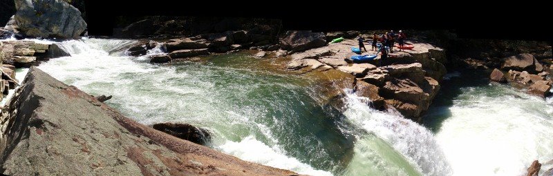
 Panoramic of part of the 420. One of our group hiked up to the road from this point, bringing us down to 7. Adam and Oliver hiding in the lower right.
 Sweet Kicker Falls. We ran out of an eddy on river right, charging across the grain of the current, and then down onto the kicker.
 Chris Flavin on a perfect 12' falls.
 Zero to sixty.
While scouting this falls, I began to slide down the super slick, polished granite. I looked for something to grab, or a dry place to jump, but finding neither, I decided to commit to the boating line, and ran/skidded/fell down the slide, and jumped over the lip into the pool. I surfaced just in front of the river right wall, and got out on a convenient rock to examine my options.
 That was dumb. JB Seay feeling foolish at Zero to Sixty. Photo by Phil Higgins.
Adam tried to tow me across the current and out of the LZ, but that did not go well, and I ended up floating back into a cave (to the right of the above photo) out of breath with my elbow pads down around my fingertips, and my pants pulled completely off. I was able to chimney up the back of the cave, and a quick hand from Oliver got me back up on top so I could try the drop in my kayak.
Shortly below there, the 4 Brits wisely decided to take out at a gauging station, and sort out their shuttle up on the road. We continued downstream, passing the Marble Fork and picking our way through boulder gardens in a shallow, widened streambed. With more water, I imagine this section is great fun, but the combination of low flows, being tired, and boat breaking paranoia wore on me. I eventually hiked up to the road, getting nearly covered in burrs and the fine, talcum powdery soil of the canyon walls. I lucked into a ride back to the put-in from our new boating friends. They were on their way back from a supplies run, and took me and all my filthy gear right to Adam's car. Adam and Oliver finally made it down to the confluence just before dark fell, with mixed reviews of the last few miles of river.
I have a few more photos on my picasa account, if you are really bored.
If you know the names of any of the pictured rapids, post a comment or drop me an e-mail.
Stay tuned for day two on the Middle Kaweah.
6 comments:
And I quote: "You guys need to puts more dates on when you do those snowmelt runs."
Every year is different. The spontaneity of each trip adds to the fun. You never know exactly when these runs will go. We make educated guesses, monitor flow chart, and communicate with sources around the region of interest - a lot. Sorry, no dam schedule out here.
I realize that there is no schedule of snowmelt based rivers, but dates of when people get on runs helps correlate when things go based on conditions. A lot of the blog posts and trip reports are written once folks get home, so its hard to tell if a run was done in early june or mid july. It makes it harder for out of towners who don't necessarily have a network of people to check in with. You may notice that I never got on boof.com and said "Hey fellers, when will upper cherry run this year?" That would be unrealistic, but being able to see when people got into places over several seasons would help with the educated guessing when I'm trying to put my wife and kids on hold so I can go kayaking for a week. It was a relatively light hearted comment, although if putting a date on when you ran a river is too much info, then I'm sorry you feel that way.
By the way, 90% of my boating has nothing to with dam releases. I pray for rain.
What are you guys boating on out there right now? Dam releases?
Hi Pot I'm kettle!
We take the boating where we can get it eh?
JB-
One thing that I didn't say that I intended to write earlier is that I enjoyed reading your write ups and the pics are great. Overall, its good beta. I got my back up about being told that we all "need" to do something that doesn't have all that much impact on the overall information - unless the reader is 3000 miles away and have a tight timeline with limited contacts; I get it. I've boated out East and I know it isn't all dam release. Fall hurricanes are like a Jackson Hole pow day - absolute madness and super sick. But the boaters I found out there are way nicer and friendlier than skiers when it's epic.
What I have found interesting over the years is that some power companies can make the dam release schedule a big freaking secret. AW and other organizations work really hard negotiating flow compromises and I hope that the scheduled releases continue to generate adequate to high interest so we can keep them and develop more. Most of my favorites are natural flow and I can string things together year round, but I try to get to as many releases as possible. But still, some stuff is so locked down, its stupid. So there is some sensitivity. Which I'm sure you can relate to.
I'm rambling but I have one more thing to say. I find it interesting that you use the spread of early June to mid July. I've seen perfect snowpacks get nuked in early to mid May - sending Kimshew dreams to the reservoir while I was stuck in class. I've also been on South SIlver nearing the end of July. I sometimes wonder how much of my life I spent digging around Shackleton's Dreamflows and USGS and comparing it to Holbek and Stanley and various notes. But you do have an interesting spreadsheet idea. I'm sure someone has one - color coded and everything. I know Stookesberry has one in his head and it dates back to about 1999.
Yes, we take boating where we can get it. So Kettle, maybe I'll see you on the water some day.
Sam
(Pot)
Oh, so what did the other guy say?
He essentially said don't pick on typos, then deleted it a few minutes later.
I hear you on the gauge prowling, I did as much as I could in advance of this trip. I think I have a much better idea of the lay of the land and character for future trips, which I hope t make. California in the summer is all you can want.
I'm glad you came back and clarified some more, Thanks!
If you ever need WV beta, don't hesitate to get in touch.
Post a Comment