.jpg)
High Ridge Run collects itself in a small drainage below one of the steepest parts of the Front. At the put in, the creek is tiny, and grows slowly as it drops 1000' in two miles toward the North Fork of the South Branch of the Potomac.
Harpers Ferry boater Mike Moore has been scouting this creek for years. I knew it as "Mike Moore's Secret Creek" long before I knew its name or location. He has scouted, checked on access, chatted with landowners and fisherman, and spent weekend after weekend clearing logs from drops and learning the creek. He must have a good Tom Sawyer speech too, because he drafted his friends to help him get things boatable. The hard work paid off, and I can't thank those guys enough for their effort.
Saturday morning found nearly twenty people hiking up a forest road to the top of the creek.

Sometimes the gate is open, but this was not one of those weekends. We climbed 1400' in two miles before turning left and crossing another mile down into the very top of the creek. I was soaked in sweat and hurting by the time it was done. I am terrible at pacing myself, and currently have sub-optimal fitness. (which begs the question of why I did it again the next day)

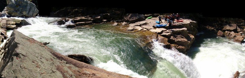
The hikers filtering down into the put-in, at the highest runnable portion of the creek.

Chuck Morris on the put in rapids.
 The second significant drop: a transition onto a slab and then out.
 Busy Busy Busy.
 Whoah. Long day for this man, but he did it with a smile and a game effort. Big boat on a little creek.
 Sam Burke in one of the more boulder filled rapids on the upper section of creek. The rock to Sam's left dished out a lot of abuse, from scraped knuckles to full on swims. Above this drop is a 12' falls, and a 10' slide, and some other stuff all in sequence with no real stop. I ran it on verbal directions from Chuck, who got them from Mike Moore, who spent much of the day standing on various perches giving out directions like an air traffic controller. (or a mountaintop guru of rapid lines) Beta from Mike, and from Don Smith, who had also been on the creek previously, made for confident probing and bombing away.
 Chuck Morris keeping his bow up in a tight LZ. Just below this ledge is a large, broken tree spanning the river. While you portage around the tree, you can take a moment to scout the confluence canyon.
 Don Smith runs the second of three drops in this sweet little crux gorge. 20' entrance falls, a 12' or so kicker in the middle, then a twisting slide to exit. At this point on the run, you have traveled about 1/2 a mile and dropped 400'. Awesome.
 Geoff Calhoun finishes up the third slide.
A decent sized fork of the creek is entering on the river right, directly into the bottom slide. Beautiful place. The pace eases up somewhat from here down, and our large group of nearly twenty ended up stretched over several hundred yards of creek. Eventually, a handful of us, (chasing Jason Beakes) started moving really fast out in front and we split into two groups.
 By really fast I mean we didn't scout here.
 Or here. Or countless other ledges and turns. The work Mike and crew did, the super friendly nature of the creek, and some very comfortable probes out front made quick work of the bottom 1 1/2 miles of creek, which were still dropping at a 400-500fpm pace.
 Mild mannered elementary school teacher Robert Miller genteelly makes his way down a babbling brook.
 Don Smith loads up for the best boof on the creek. Taller than it looks.
 Eric Amason charges around the corner and prepares to log dodge.
The creek quieted down even more below here, and was straightforward read and run to the takeout. These photos are by no means a complete representation of the creek, there is lots more I didn't have time or angles to photograph. Think of this blog post like a movie trailer, it tells enough of the story to get your attention, but by no means is it the whole thing.
High Ridge Run is an incredible combination of friendly streambed and gradient. Every drop is runnable, with countless 6-10' ledges and unique falls and rapids. It is a busy creek; there are no real pools anywhere along the run, and an out of control line can take a long time to recover from. Eddies were minimal at times, as can be expected for a micro-creek with this kind of gradient.
More pictures from our run can be seen on my picasaweb album. Hopefully I can add more pics and some video as the media other guys shot becomes available.
For Saturday's run, the NFSB Potomac crested near 11,000 cfs at the Cabins gauge. I don't think there is a direct correlation, but that gauge climbing high combined with heavy local rains is the best indicator that High Ridge Run is flowing. Seneca Creek was also bankfull in nearby Onego, WV on Saturday. A group of us went back in on Sunday, and while the creek was fun, it was really too low, the watershed is quite small for this creek, so catch it on the way up and don't delay, it won't hold it water for long.
Update: an addendum from Mike Moore himself. I'm just gonna quote his e-mail:
"Tim Gavin felt that the Allegany Front held secrets that us kayakers ought to know about, but we were all pre occupied with the Blackwater and North Fork @ the time, and could not be distracted with other things!
Jeff Cogle and I renewed the interest, flyovers on Google Earth and poring over the raised relief topo map Jeff has.
I was the 1st to step and see with boaters eyes, could not believe what I was seeing only a 1/2 mi up the creek bed, Chris Good and I went up to the confluence drop that same day, making it just @ dark. It looked like fantasy land, looking up @ the confluence drop in the fading light.
Back in the following weekend, and following 4 weekends, with Jeff Cogle, Clarke & Jeremy Gesey to begin working away and scouting the Upper section, which was dubbed The Wet Dream Section. Truly amazing section of whiteh2o, more boofs than any creek around, and hardly any boulders.
Exploring out of the High Ridge drainage has been fruitful as well, the whole Allegany Front is peppered with classic class 4-5 creeking in the wettest of times. Its nice to see a new place with world class runs when all of our west side creeks are blown out and our signature east side run[ Seneca] is too high.
So kudos to Timmy Gavin for the thought, and the inspiration to keep searching and discovering.
Somehow, I think Tim was along for that 1st D!"
9 comments:
Nice nice nice nice. I'm so keeping HRR on my list.
Mike,
You absolutley know that Tim was your wing man on the first D. No doubt! Thanks for putting in the extra personal effort for the greater good of the entire boater community.
Simcoe
"I am terrible at pacing myself, and currently have sub-optimal fitness. (which begs the question of why I did it again the next day)"
I'm gonna say that's exactly why you did it the next day (not to mention the great kajaking)!
Nice JB. Wish I could have been there.
This creek is the ideal for anyone who has ever looked at a map and said "hey, that's steep, I wonder whats in there"
MV, on Sunday I had made up my mind that I was late, and did not feel like doing that hike again. But shortly afterward I felt like a big baby and pointed the car in the right direction to meet some buddies and go boating. I did not conquer the hill, but I survived it with help from my friends. (and a thrown together backpack system)
It's things like this that make an old man wish for more of everything but most of all youth .Don't waste it on I wish I would have just get out there and do it .JB your still young and having fun keep it up .
That place looks great for getting wet and to get the blood pumping !!!
Looks like tons of fun, and what a great crew this past weekend. Wish I'd been around for the fun. Great job, Mike.
Great write up, wish I came out, I was expecting tons of snow on the road making that hike near impossible. Ended up paddling Deep Creek into the Top Yough, amazing run close to the cabin.
That hike really did suck..... great write up JB, great paddling with you again!
Awesome blog post! Thanks for the report and great photos.
Post a Comment